2024. 9. 15. 11:57ㆍ■ 국제/CANADA

스토니 크릭 다리는 CPR의 레벨스토크 지부의 산악 지류에 있는 로저스와 플랫 크릭 사이의 코노트 트랙에 있는 글레이셔 공원의 동쪽 끝에 있습니다. 스토니 크릭 다리는 길이가 600피트가 넘고 개울 위가 325피트입니다.
The Stoney Creek Bridge is just within the East end of Glacier Park on the Connaught track between Rogers and Flat Creek on the Mountain Sub of the Revelstoke Division of the CPR. Stoney Creek Bridge is over 600' long and 325' above the creek.
5개 언어
|
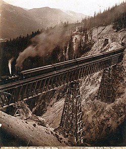
CP 화물 열차, 스토니 크릭 다리, 1988
|
|
| 북위 51°22′48″ 서경 117°27′58″ | |
| 철도 | |
| 스토니 크릭 | |
| 로저스 패스 | |
| 캐나다 태평양 철도 | |
| 트러스 아치교 | |
| 단철 | |
| 148미터(486피트) | |
| 82미터(270피트) | |
| 102미터(336피트) | |
| 해밀턴 브릿지 회사(1893), 캐나다 브릿지 회사(1929) | |
| 1894 | |
| 1885 다리 | |
|
|
|
스토니 크릭 브리지 는 브리티시 컬럼비아 남동부에 있는 캐나다 태평양 철도 (CP) 트러스 아치 입니다 . 스토니 크릭을 가로지르는 이 단일 선로 교차로는 레벨스토크 와 골든 사이의 글레이셔 국립공원 에 있습니다 .
1885년 목조 다리
[ 편집하다 ]Stoney Creek은 지금까지 건설된 가장 높은 목조 교량이었고, 당시 구조적 높이가 아닌 데크 높이를 기준으로 북미에서 두 번째로 높은 교량이었습니다. [ 1 ] 데크 높이는 교량 데크에서 아래의 지면이나 수면까지의 최대 수직 낙차입니다. 그러나 다양한 출처에서 이 목조 구조에 대한 다양한 높이 측정값이 나왔습니다.
3개의 탑의 높이는 각각 33미터(109피트), 60미터(196피트), 10미터(34피트)였습니다. 계획 및 사진 증거를 사용하여 측정치를 다시 계산하면 데크 높이가 84미터(275피트)임을 나타냅니다. [ 2 ] 52미터(172피트) 및 49미터(161.5피트) 길이의 Howe 트러스가 3개의 기둥에 걸쳐 있었습니다. [ 1 ]
좁은 협곡의 협소한 작업 공간과 불안정한 암석 기초로 인해 공사가 늦어졌습니다. 높은 탑의 기초를 덮친 폭우 로 인해 2일간의 공사가 중단되었습니다. 산불로 다리 건설에 필요한 목재 14대분이 소실된 후, 벌목꾼들은 손실을 메우기 위해 추가로 나무를 베어야 했습니다. 1885년 8월 초에 완공된 공사는 7주가 걸렸는데, 여기에는 두 명의 노동자가 사망하고 악천후로 인해 10일이 손실되었습니다. 셀 커크 산맥 의 동쪽 경사면에 있는 매우 높은 다리는 모두 공사에 어려움이 있었지만, 이 마지막 다리가 가장 문제가 많았습니다. [ 3 ]
동부 브리티시 컬럼비아의 산악 지형을 정복하는 데 필요한 높은 목재 다리를 건설하는 데 있어 CP만큼 뛰어난 철도는 없었습니다. [ 1 ]
1894년 철교
[ 편집하다 ]건설
[ 편집하다 ]1893년에 샐먼암 채석장 에서 3,000대의 차량에 실린 암석이 레일로 옮겨졌습니다 . 공사 중에 떨어진 암석에 맞은 목수가 계곡 바닥으로 떨어져 치명적인 부상을 입었습니다. [ 4 ] 그해 말에 Hamilton Bridge Co. 직원이 떨어져 사망했습니다. [ 5 ] 이 회사는 기존 교차로를 높이 82m(270피트), 길이 148m(486피트)의 구조물로 교체했으며, 여기에는 102m(336피트)의 강철 아치 경간이 포함되었습니다. [ 6 ] 하중 테스트 후, 공사는 1894년 봄에 완공되고 개장할 때까지 중단되었습니다. [ 1 ] [ 7 ] 이 설계는 산악 지역 기관차 두 대의 무게를 합친 것을 편안하게 지탱할 수 있었습니다. [ 6 ]
강하게 하는 것
[ 편집하다 ]더 무거운 기관차를 다루기 위해 CP는 기존 교량 옆에 34m(111ft) 측면 앵커 스팬이 있는 새로운 95m(311ft) 캐틸레버 데크 트러스로 구조물을 교체할 것을 제안했습니다. 그러나 협곡의 부적절한 암석 기초로 인해 이 아이디어는 경제적이지 않았습니다. 대신 기존 아치 외부에 트러스 아치를 배치하여 각 측면을 1.5m(5ft) 넓힐 것입니다. [ 6 ]
1929년에 Canadian Bridge Co.가 설치를 맡았고, 데크 격자 거더 스팬을 데크 플레이트 거더 로 교체했습니다 . [ 8 ] 이 설계는 총 중량이 1,100톤인 기관차 4대를 지탱할 수 있었습니다.1970년에 대량 상품 단위 열차 도입을 위해 하중 용량이 재평가되었습니다.1999년에 또 다른 강도 평가가 수행되었습니다. [ 6 ] 서쪽 접근로는 협곡을 가장 좁은 지점에서 건너기 위해 선로에 날카로운 굽이가 있습니다. [ 8 ] 이 선로 곡률은 구조물의 서쪽 끝에 상당히 큰 원심력을 가하여 현재 열차 속도를 시속 40킬로미터(25mph)로 제한합니다. [ 6 ]
1988년 서쪽으로 가는 교통을 위해 하부 Macdonald Track이 개통된 이후 , Connaught Track 의 Stoney Creek 아치는 주로 동쪽으로 가는 가벼운 열차를 처리했습니다. 지난 15년 동안 피로 손상이 상당했지만, 이 다리는 예상대로 장수명을 유지하고 있습니다. 그러나 현재와 미래의 열차 하중을 안전하게 지탱하기 위해서는 일부 결함 있는 부분을 강화해야 할 수도 있습니다. [ 6 ]
사고
[ 편집하다 ]2015년에 서쪽으로 가는 화물 열차의 6량이 다리에서 탈선했습니다. Mount Macdonald Tunnel이 환기되고 있었기 때문에 기차는 동쪽으로 가는 경로로 방향을 변경했습니다. 이 사고는 기차가 가파른 경사에서 추진력을 잃고 다리 위에 있는 차량과 함께 멈췄을 때 발생했습니다. 그러나 곡선에서 다시 시작하자 기차 앞뒤에 있는 더 무거운 차량이 더 가벼운 중간 차량을 선로에서 들어올렸습니다. [ 9 ]
저명
[ 편집하다 ]1894년 개통 당시 다리의 높이는 7위였습니다.Garabit
Viaduct (1885) 124미터(407피트)
Loa Viaduct (1888) 102미터(336피트) [ 10 ]
Pecos River High Bridge (1892) 98미터(321피트) [ 11 ]
Malleco Viaduct (1890) 96미터(315피트) [ 12 ]
Kinzua Viaduct (1882) 92미터(301피트) [ 13 ]
Young's High Bridge (1889) 86미터(283피트)
Stoney Creek Bridge (1894) 82미터(270피트)
더 이상 세계 등급은 아니지만 이 교량은 서부 캐나다의 레스브리지 고가교 (1909년)의 96미터(314피트)에 이어 2위를 차지했습니다.
다리와 그 위치는 상징적인 지위를 얻은 수많은 CP 홍보 사진의 주제였습니다. 가장 잘 알려진 사진 중에는 CP 특별 사진 작가 Nicholas Morant가 철도의 주력 유선형 차량이었던 The Canadian을 특징으로 삼은 사진이 있습니다. [ 14 ] 1980년대 중반, 철도를 홍보하는 여러 TV 광고가 다리 현장에서 촬영되었습니다. [ 8 ]
측선
[ 편집하다 ]Stoney Creek은 Mountain Subdivision의 Mile 77.7 에 있는 2,582m(8,471ft) 사이딩입니다 . 서쪽에는 Glacier (Mile 85.5)가 있고 동쪽에는 Griffith(Mile 71.7)가 있습니다. 다리(Mile 76.2)는 전체적으로 동쪽 방향으로 바로 북서쪽에 있습니다. [ 15 ]
1988년 다리
[ 편집하다 ]하류, Connaught Track 다리 아래 약 150미터(500피트)에 7개 경간, 210미터(700피트) 길이의 Macdonald Track 다리가 있습니다. [ 16 ] 1986년 가을에 완공된 [ 17 ] John Fox 고가교 의 경간은 1987년 7월 초부터 이 다리의 남쪽 끝에서 하역되었습니다. [ 18 ] 1988년 12월 12일, 석탄을 운반하던 첫 번째 수입 열차가 다리를 지나 여행 시간을 한 시간 단축했습니다. [ 16 ]
참고문헌
[ 편집하다 ]- ^다음으로 이동:a b c d "캐나다 다리 90~100미터".www.highestbridges.com.
- ^ "CPR의 1885년 스토니 크릭 다리의 높이" . www.webpraxis.ab.ca .
- ^ Finch, David AA (1987). "1884-1930년 BC Glacier National Park의 Canadian Pacific Railway 역사" (PDF) . www.parkscanadahistory.com . 캐나다 환경부. pp. 22–24.
- ^ "The Daily Colonist, 1893년 5월 9일" . www.archive.org . 1893. p. 2.
- ^ "The Daily Colonist, 1893년 11월 7일" . www.archive.org . 1893. p. 2.
- ^다음으로 이동:a b c d e f Unsworth, JF "재활된 강철 아치 철도 교량의 하중 용량 평가". Canadian Pacific Railway.CiteSeerX 10.1.1.531.1704 . {{cite journal}}: 저널 인용에는 |journal=( 도움말 ) 이 필요합니다.
- ^ "Victoria Daily Times, 1893년 11월 28일" . www.newspapers.com . p. 3. 지난 화요일 아침의 가장 성공적인 테스트 이후 Stoney Creek 다리 공사는 내년 봄까지 중단되었습니다.
- ^다음으로 이동:a b c 부스 1991, 15-16쪽.
- ^ "Golden Star, 2016년 7월 8일" . www.thegoldenstar.net . 2016년 7월 8일.
- ^ "로아 육교" . www.highestbridges.com .
- ^ "페코스 하이 브릿지" . www.tshaonline.org .
- ^ "말레코 고가교" . www.highestbridges.com .
- ^ "90~100미터 다리: 미국" . www.highestbridges.com .
- ^ "캐나다 철도, 1973년 6월" (PDF) . www.exporail.org . p. 179.
- ^ "2003 시간표" (PDF) . www.mapleleaftracks.com . pp. 13–15.
- ^다음으로 이동:a b Steed, Roger G. (1993).셀커크의 캐나다 태평양(2권). BRMNA, 캘거리, 앨버타. 20쪽.ISBN 0-919487-44-0.
- ^ 부스 1991 , 50쪽.
- ^ 부스 1991 , 25C쪽.
참고문헌
[ 편집하다 ]- 부스, 얀(1991). 셀커크의 캐나다 태평양: 로저스 패스의 100년, 2판 . BRMNA, 캘거리, 앨버타. ISBN 0-919487-15-7.


Stoney Creek Bridge
-
k
|
CP freight train, Stoney Creek Bridge, 1988
|
|
| 51°22′48″N 117°27′58″W | |
| railway | |
| Stoney Creek | |
| Rogers Pass | |
| Canadian Pacific Railway | |
| truss arch bridge | |
| Wrought iron | |
| 148 metres (486 ft) | |
| 82 metres (270 ft) | |
| 102 metres (336 ft) | |
| Hamilton Bridge Co. (1893), Canadian Bridge Co. (1929) | |
| 1894 | |
| 1885 bridge | |
|
|
|
Stoney Creek Bridge is a Canadian Pacific Railway (CP) truss arch in southeastern British Columbia. This single-track crossing over Stoney Creek is in Glacier National Park, between Revelstoke and Golden.
1885 wooden bridge
[edit]Stoney Creek was the highest timber bridge ever built, and at the time was the second highest bridge in North America[1] with reference to deck height, rather than structural height. Deck height is the maximum vertical drop from the bridge deck to the ground or water surface below. However, various sources yield a range of height measurements for this wooden structure.

The heights of the three towers were 33 metres (109 ft), 60 metres (196 ft), and 10 metres (34 ft). Recalculating the measurement using the planning and photographic evidence indicates an 84-metre (275 ft) deck height.[2] Howe trusses, measuring 52 metres (172 ft) and 49 metres (161.5 ft), spanned the three piers.[1]
The confined workspace of the narrow gulch and the unstable rock foundation slowed construction. A flash flood, which buried the foundations of the high tower, cost two days of work. After a forest fire consumed 14 cars of lumber for the bridge, loggers had to fell additional trees to replace the loss. Completed in early August 1885, construction took seven weeks, which included ten days lost owing to the death of two workers and wet weather. Although each of the very high bridges on the east slope of the Selkirk Mountains had been construction challenges, this final one proved the most problematic.[3]
No other railway has ever matched CP in building as many high timber bridges as were required to initially conquer the mountainous terrain of eastern British Columbia.[1]
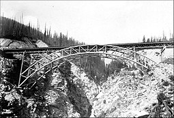
1894 steel bridge
[edit]Construction
[edit]In 1893, 3,000 carloads of rock were railed from a Salmon Arm quarry. During construction, a carpenter struck by dislodged rock sustained fatal injuries on falling to the bottom of the ravine.[4] A Hamilton Bridge Co. employee fell to his death later that year.[5] This company replaced the existing crossing with an 82-metre (270 ft) high, 148-metre (486 ft) long structure, incorporating a 102-metre (336 ft) steel arch span.[6] After load testing, work was suspended until the spring 1894 completion and opening.[1][7] The design could comfortably support the combined weight of two mountain region locomotives.[6]
Strengthening
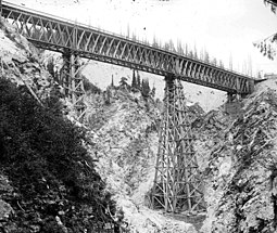
[edit]To handle heavier locomotives, CP proposed to replace the structure with a new 95-metre (311 ft) cantilever deck truss with 34-metre (111 ft) flanking anchor spans, built adjacent to the existing bridge. However, the unsuitable rock foundation of the canyon made the idea uneconomical. Instead, truss arches, positioned outside of the existing ones, would widen each side by 1.5 metres (5 ft).[6]
In 1929, the Canadian Bridge Co. undertook the installation, and replaced the deck lattice girder spans with deck plate girders.[8] The design could support four locomotives with a combined weight of 1,100 tons. In 1970, the load capacity was re-evaluated for the introduction of bulk commodity unit trains. In 1999, another strength evaluation was conducted.[6] The western approach comprises a sharp bend in the track to cross the gorge at its narrowest point.[8] This track curvature places considerably greater centrifugal forces on the west end of the structure, which limits current train speeds to 40 kilometres per hour (25 mph).[6]
Since the opening of the lower Macdonald Track in 1988 for westbound traffic, the Stoney Creek arch on the Connaught Track has primarily handled the lighter eastbound trains. Although fatigue damage during the prior 15 years was considerable, the bridge maintains an expected long life. However, to safely sustain present and future train loads, some deficient parts may require strengthening.[6]
Accident
[edit]In 2015, six cars of a westbound freight derailed on the bridge. The train had diverted to the eastbound route because the Mount Macdonald Tunnel was being vented. The incident occurred when the train lost momentum on the steeper grade and stopped with the cars on the bridge. However, restarting on the curve caused the heavier cars at the front and rear of the train to lift the lighter middle cars from the track.[9]


Notability
[edit]When opened, the 1894 bridge ranked seventh in height:
Garabit Viaduct (1885) 124 metres (407 ft)
Loa Viaduct (1888) 102 metres (336 ft)[10]
Pecos River High Bridge (1892) 98 metres (321 ft)[11]
Malleco Viaduct (1890) 96 metres (315 ft)[12]
Kinzua Viaduct (1882) 92 metres (301 ft)[13]
Young's High Bridge (1889) 86 metres (283 ft)
Stoney Creek Bridge (1894) 82 metres (270 ft)
Although no longer world rating, the crossing ranks second to Lethbridge Viaduct (1909) 96 metres (314 ft) in Western Canada.
The bridge and its locale have been the subject of numerous CP promotional photographs that have gained iconic status. Among the most recognized are those by CP special photographer Nicholas Morant featuring The Canadian when it was the railway's flagship streamliner.[14] In the mid-1980s, several television commercials to promote the railway were filmed at the bridge site.[8]
Siding
[edit]Stoney Creek is a 2,582-metre (8,471 ft) siding at Mile 77.7, Mountain Subdivision. Adjacent to the west is Glacier (Mile 85.5), and east is Griffith (Mile 71.7). The bridge (Mile 76.2) is immediately northwest in an overall eastward direction.[15]
1988 bridge
[edit]Downstream, and about 150 metres (500 ft) below the Connaught Track bridge, is the seven-span 210-metre (700 ft) long Macdonald Track bridge.[16] Completed in fall 1986,[17] the spans for the John Fox viaduct were unloaded at the south end of this bridge from early July 1987.[18] On December 12, 1988, the first revenue train, hauling coal, passed over the bridge, and reduced an hour of the journey.[16]
References
[edit]- ^ Jump up to:a b c d "Canada Bridges 90 to 100 meters". www.highestbridges.com.
- ^ "Height of the CPR's 1885 Stoney Creek Bridge". www.webpraxis.ab.ca.
- ^ Finch, David A.A. (1987). "A History of the Canadian Pacific Railway in Glacier National Park, B.C., 1884–1930" (PDF). www.parkscanadahistory.com. Environment Canada. pp. 22–24.
- ^ "The Daily Colonist, 9 May 1893". www.archive.org. 1893. p. 2.
- ^ "The Daily Colonist, 7 Nov 1893". www.archive.org. 1893. p. 2.
- ^ Jump up to:a b c d e f Unsworth, J.F. "Evaluation of the Load Capacity of a Rehabilitated Steel Arch Railway Bridge". Canadian Pacific Railway. CiteSeerX 10.1.1.531.1704. {{cite journal}}: Cite journal requires |journal= (help)
- ^ "Victoria Daily Times, 28 Nov 1893". www.newspapers.com. p. 3. Work on the Stoney creek bridge has been discontinued until next spring after a most successful test last Tuesday morning.
- ^ Jump up to:a b c Booth 1991, pp. 15–16.
- ^ "Golden Star, 8 Jul 2016". www.thegoldenstar.net. 8 July 2016.
- ^ "Loa Viaduct". www.highestbridges.com.
- ^ "Pecos High Bridge". www. tshaonline.org.
- ^ "Malleco Viaduct". www.highestbridges.com.
- ^ "Bridges 90 to 100 meters: United States". www.highestbridges.com.
- ^ "Canadian Rail, June 1973" (PDF). www.exporail.org. p. 179.
- ^ "2003 timetable" (PDF). www.mapleleaftracks.com. pp. 13–15.
- ^ Jump up to:a b Steed, Roger G. (1993). Canadian Pacific in the Selkirks (Volume Two). BRMNA, Calgary, Alberta. p. 20. ISBN 0-919487-44-0.
- ^ Booth 1991, p. 50.
- ^ Booth 1991, p. 25C.
References
[edit]- Booth, Jan (1991). Canadian Pacific in the Selkirks: 100 Years in Rogers Pass, second edition. BRMNA, Calgary, Alberta. ISBN 0-919487-15-7.


'■ 국제 > CANADA' 카테고리의 다른 글
| 진실과 화해를 위한 국가적 날 (0) | 2024.10.01 |
|---|---|
| “우리 늙어도 손주 자랑돼볼까”...84세·80세 부부 건강비결에 세계가 놀랐다 (0) | 2024.09.22 |
| 러 탱크, 우크라 자폭 드론 막으려 고무판 덧댔다 (0) | 2024.09.10 |
| 서울 2.5배 태운 美캘리 산불…캐나다 재스퍼 100년만에 최대 피해 (0) | 2024.08.05 |
| 캐나다 산불 (0) | 2024.08.03 |