2022. 9. 28. 11:41ㆍ■ 자연 환경/Weather
Fiona erodes large swaths of P.E.I.'s shoreline, satellite images show (msn.com)
Fiona erodes large swaths of P.E.I.'s shoreline, satellite images show
The Canadian Space Agency has posted two astonishing satellite photos of Prince Edward Island showing how much of the coastline Hurricane Fiona has swept into the sea. The first photo was taken on Aug. 21, the other on Sept. 25, a day after Fiona lashed th
www.msn.com

Fiona erodes large swaths of P.E.I.'s shoreline, satellite images show
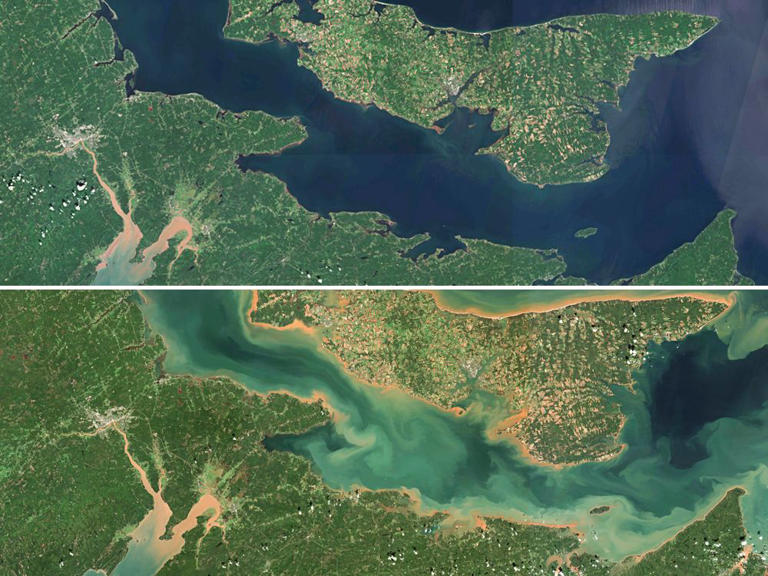
The Canadian Space Agency has posted two astonishing satellite photos of Prince Edward Island showing how much of the coastline Hurricane Fiona has swept into the sea.
The first photo was taken on Aug. 21, the other on Sept. 25, a day after Fiona lashed the island with hurricane-force winds that exceeded 140 kilometres per hour.
The second photo clearly shows the clear blue waters around the Island streaked by huge underwater plumes of sand and soil extending far offshore.
The agency posted a tweet saying the photos illustrate “the extent to which the extreme wind and wave action of the storm has churned up the sea floor and eroded the coastline.”
The space agency said the images were from the European Union, containing modified Copernicus Sentinel-2 data.
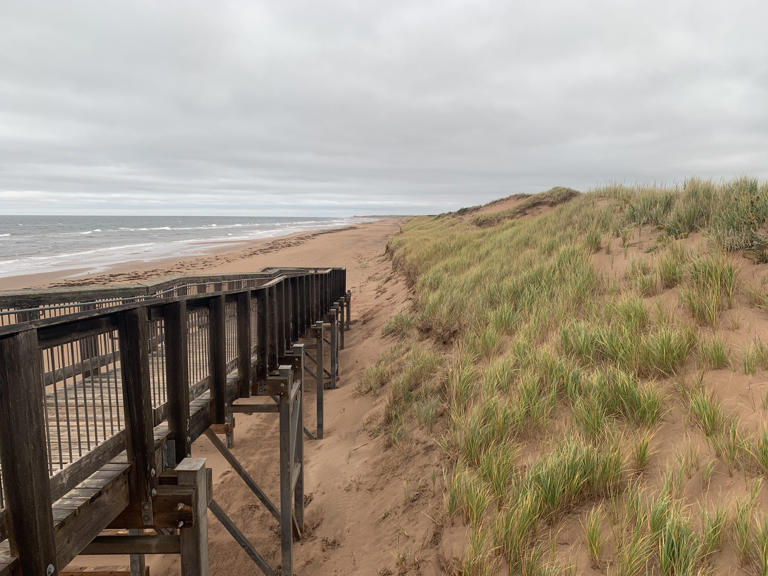
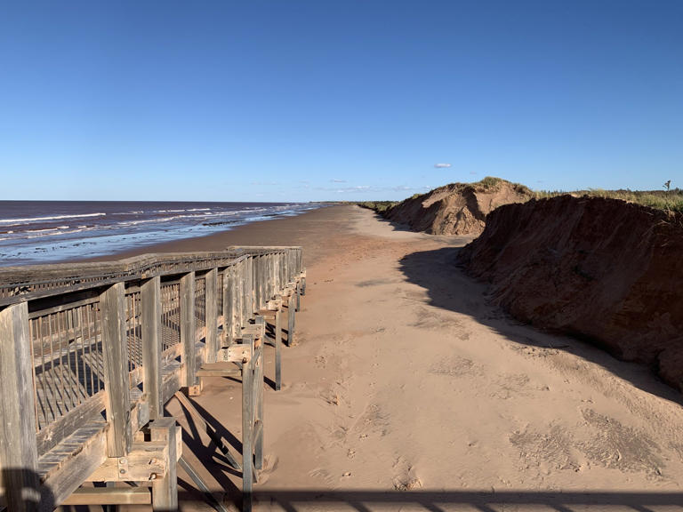
Fiona’s violent waves and wind denuded about 40 per cent of the observed coastline in Brackley Beach and Cavendish Beach, located within P.E.I. national park, said Libby George, program coordinator with Coastie Canada and a Phd candidate in Coastal Geomorphology at University of Windsor.
The group is estimating the storm’s impact with help from user-submitted photos from fixed locations to study erosion in natural areas over time.
“We’re observing about a 40 per cent volumetric loss, which works out to around 30 cubic metres per metre along shore,” said George, calling the losses “significant.”
By comparison, Hurricane Dorian in 2019 resulted in “four to five cubic metres of loss,” she added. The storm also toppled Teacup Rock, an iconic sandstone stack located in Thunder Cove Beach.
Not only is there volumetric loss, but the sand dunes have also retreated around seven to 10 metres based on current observations, George said.
The loss of dunes is troubling because they protect beaches from the impact of storms, Jennifer Stewart told the Canadian Press. Stewart, who’s been working with the P.E.I. national park since 2000, said Fiona caused the most severe coastal erosion she has seen in her career.
It could take anywhere between a few years up to a decade for the seaboard to return to its pre-storm state, said George. Successive storms may hinder recovery of the dunes, she added.
— Additional reporting from Canadian Press
'■ 자연 환경 > Weather' 카테고리의 다른 글
| Boats in the streets, cars in the sea: Fort Myers Beach pummeled by Ian (0) | 2022.10.02 |
|---|---|
| The Freakiest Things Ever Discovered Frozen in Ice (0) | 2022.10.01 |
| Hurricane Fiona has destroyed much, but the Sable Island horses survive (0) | 2022.09.28 |
| 600년간 물에 잠겼던 불상이 바깥으로..가뭄이 바꾼 세계 (0) | 2022.09.27 |
| 허리케인 피오나, 캐나다 동부 강타..50만 가구 정전 (0) | 2022.09.25 |