2021. 3. 20. 01:09ㆍ■ 여행/세계 여행 안내
Grinnell Glacier is in the heart of Glacier National Park in the U.S. state of Montana. The glacier is named for George Bird Grinnell, an early American conservationist and explorer, who was also a strong advocate of ensuring the creation of Glacier National Park. The glacier is in the Lewis Range and rests on the north flank of Mount Gould at an altitude averaging 7,000 feet (2,100 m), in the Many Glacier region of the park.[3]
The glacier has been one of the most photographed glaciers in the park and many of these photographs date back to the mid 19th century during the late Little Ice Age. When compared with images taken over subsequent years, the glacier has obviously retreated substantially. In 1850, Grinnell Glacier measured 710 acres (2.9 km2), including the area of The Salamander Glacier, an ice apron or shelf glacier that used to be attached to Grinnell, but is now separate. By 1993, Grinnell Glacier measured 220 acres (0.89 km2) and The Salamander measured 57 acres (0.23 km2).[4]
Between 1966 and 2005, Grinnell Glacier lost almost 40 percent of its acreage.[2] Glaciologists have predicted that if carbon dioxide levels increase at a worst-case scenario, all the glaciers in the park, including Grinnell, will disappear by the year 2030.[5][6] However, under a modest increase in overall carbon dioxide levels, some glaciers will remain until the year 2277.[6]
Gem Glacier, one of the smallest remaining glaciers in the park, is located on the Garden Wall above Grinnell. Repeat photography taken between the years 1938 and 2009 (as shown below) show that Grinnell Glacier has retreated significantly over that period. The Salamander and Gem Glaciers have shown little change in area over the same period of time. The Salamander receives its name for its shape and its coloring, which comes from the serratia bacteria that grows on it.
The glacier can be reached after a 6-mile (9.7 km) hike from a trailhead beginning at Swiftcurrent Lake. The trail has an altitude gain of just over 1,600 ft (490 m), with the majority of that in the second half of the hike.[7]

A view of the Grinnell Glacier after hiking the trail leading to it, in 2012.
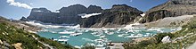
A view of Grinnell Glacier from the end of the hiking trail in August, 2019

View from Grinnell Glacier Overlook
See also[edit]
- Retreat of glaciers since 1850
- List of glaciers in the United States
- Glaciers in Glacier National Park (U.S.)
| Wikimedia Commons has media related to: |
References[edit]
- ^ "Grinnell Glacier". Geographic Names Information System. United States Geological Survey. Retrieved 2013-02-09.
- ^ Jump up to:a b "Retreat of Glaciers in Glacier National Park" (PDF). United States Geological Survey. 2010. Archived from the original (PDF) on 2012-05-11. Retrieved 2013-02-09.
- ^ Many Glacier, MT (Map). TopoQwest (United States Geological Survey Maps). Retrieved 2013-02-09.
- ^ Key, Carl H.; Daniel B. Fagre; Richard K. Menicke. "Glacier Retreat in Glacier National Park, Montana" (PDF). Glaciers of the Conterminous United States. U.S. Geological Survey. Archived from the original (PDF) on 2013-02-25. Retrieved 2013-02-09.
- ^ "Monitoring and Assessing Glacier Changes and Their Associated Hydrologic and Ecologic Effects in Glacier National Park". Glacier Monitoring Studies. U.S. Geological Survey. 2012. Archived from the original on 2013-02-18. Retrieved 2013-02-09.
- ^ Jump up to:a b Hall, Myrna H.P.; Daniel B. Fagre (February 2003). "Modeled Climate-Induced Glacier Change in Glacier National Park, 1850–2100". BioScience. 53 (2): 131–140. doi:10.1641/0006-3568(2003)053[0131:mcigci]2.0.co;2.
- ^ "Grinnell Glacier Trail". Big Sky Fishing. Retrieved 2013-02-09.
- Glaciers of Glacier County, Montana
- Glaciers of Glacier National Park (U.S.)
- Lewis Range
- Glaciers of Montana
Navigation menu
- Not logged in
- Talk
- Contributions
- Create account
- Log in
Search
Contribute
Tools
- What links here
- Related changes
- Special pages
- Permanent link
- Page information
- Cite this page
- Wikidata item
Print/export
In other projects
Languages
그리넬 빙하는 미국 몬태나주에 있는 빙하 국립공원의 중심부에 있습니다. 이 빙하는 미국의 초기 보존학자이자 탐험가인 조지 버드 그린넬(George Bird Grinnell)의이름을 따서 지어졌으며, 빙하 국립공원 의 창설을 강력히 옹호했습니다. 빙하는 루이스 산맥에 있으며 공원의 많은 빙하 지역에서 평균 7,000 피트 (2,100 m)의 고도에서 굴드 산의 북쪽 측면에 달려 있습니다. [3]
이 빙하는 공원에서 가장 많이 촬영된 빙하 중 하나였으며, 이 사진중 상당수는 리틀 빙하기후반기에 19세기 중반으로 거슬러 올라간다. 이후 몇 년 동안 찍은 이미지와 비교할 때, 빙하는 분명히 실질적으로 후퇴했습니다. 1850년, 그리넬 빙하는 그리넬에 부착하던 얼음 앞치마 또는 선반 빙하인 살라만더 빙하(Salamander Glacier)의면적을 포함하여 710에이커(2.9km2)를측정했지만 지금은 분리되어 있습니다. 1993년까지 그리넬 빙하측정220에이커(0.89 km2)와살라만더측정 57에이커(0.23 km2). [4]
1966년과 2005년 사이에 그리넬 빙하는 면적의 거의 40%를 잃었습니다. [2] 빙하학자들은 최악의 시나리오에서 이산화탄소 수치가 증가하면 2030년까지 그린넬을 포함한 공원의 모든 빙하가 사라질 것이라고 예측했습니다. [5][6] 그러나, 전체 이산화탄소 수준이 소폭 증가하여 2277년까지 일부 빙하가 남아 있을 것입니다. [6]
공원에서 가장 작은 빙하 중 하나인 젬 빙하(Gem Glacier)는그리넬 위의 가든 월(Garden Wall)에 위치해 있습니다. 1938년과 2009년 사이에 찍은 반복 사진(아래 그림과 같이)은 그리넬 빙하가 그 기간 동안 크게 후퇴했다는 것을 보여줍니다. 살라만더와 젬 빙하는 같은 기간 동안 지역에 거의 변화가 없었습니다. 살라만더는 모양과 색칠에 대한 이름을 받습니다.
빙하는 Swiftcurrent Lake에서시작하여 트레일헤드에서 6마일(9.7km) 하이킹을 한 후 도달할 수 있습니다. 트레일은 1,600 피트 (490 m)가 넘는 고도 이득을 가지고 있으며, 대부분은 하이킹 후반에 있습니다. [7]

2012년 그리넬 빙하(Grinnell Glacier)의 전경을 조망할 수 있습니다.

2019년 8월 하이킹 트레일 끝에서 그리넬 빙하의 전경

그린넬 빙하 전망에서 바라보는 경치
또한참조[편집]
| 위키미디어 공용에는 다음과 같은 관련 미디어가 있습니다. |
참조[편집]
- ^ "그린넬 빙하". 지리적 이름 정보 시스템. 미국 지질 조사. 2013-02-09를검색했습니다.
- ^ Jump up to:a B "빙하 국립공원의 빙하 휴양지"(PDF) 미국 지질 조사. 2010. 2012-05-11에 원래 (PDF)에서 보관. 2013-02-09를검색했습니다.
- ^ 많은 빙하, MT (지도). 토포Qwest (미국 지질 조사지도). 2013-02-09를검색했습니다.
- ^ 키, 칼 H.; 다니엘 비 파그레; 리처드 케이 메닉. "몬태나 주 빙하 국립공원의 빙하 휴양지"(PDF) . 미국의 빙하. 미국 지질 조사. 2013-02-25에 원래 (PDF)에서 보관. 2013-02-09를검색했습니다.
- ^ "빙하 국립 공원에서 빙하 변화와 관련 수문학 및 생태학적 효과를 모니터링하고 평가" 빙하 모니터링 연구. 미국 지질 조사. 2012. 2013-02-18에 원래에서 보관. 2013-02-09를검색했습니다.
- ^ Jump up to:a B 홀, 미르나 H.P.; 다니엘 비 파그레 (2003년 2월). "빙하 국립공원의 기후로 인한 빙하 변화, 1850-2100" 바이오 사이언스. 53 (2): 131-140. doi:10.1641/0006-3568 (2003)053[0131:mcigci]2.0.co;2.
- ^ "그린넬 빙하 트레일" 큰 하늘 낚시. 2013-02-09를검색했습니다.
|
'■ 여행 > 세계 여행 안내' 카테고리의 다른 글
| 20 tropical destinations to fantasize about in the summer (0) | 2022.07.30 |
|---|---|
| A can of Coca-Cola for $13? Prices are rising on one of Europe's most popular islands (0) | 2022.07.19 |
| 산 하나가 불상, 모든 것을 압도하는 아우라 (0) | 2021.02.14 |
| 세배만 하면 100만원?!..설날만 되면 검색 폭발하는 나라 3 (0) | 2021.02.06 |
| 아무리 봐도 해석 불가, 상상 초월.. 세계의 이색 표지판 (0) | 2021.01.23 |