2024. 6. 28. 01:41ㆍ■ 大韓民國/KOREA
■군사분계선
https://en.wikipedia.org/wiki/Military_Demarcation_Line
➠ 무료 백과 사전, 위키피디아에서
비무장지대 내 군사분계선 .
한글 군분계선 / 휴전선
한자 군사분리선 / 休전선
로마자 표기 개정 군사분계선 / 휴전선
맥쿤-라이샤우어 군사분예선 / 휴전선
군사 분계선 ( MDL )은 휴전선 이라고도 하며 북한 과 남한 사이의 육로 경계선 또는 경계선입니다.
그 경계선 양쪽에는 비무장지대 (DMZ)가 있습니다. 군사분계선(MDL)과 DMZ(DMZ)는 한국 정전협정 에 따라 설치됐다.
서해에서 남북한은 사실상의 해상 '군사분계선'과 1953년 유엔군 사령부 가 설정한 북방한계선 (NLL) 이라는 해상 경계선 으로 분단돼 있다 . 한국 정전협정. [삼]
토지의 경계
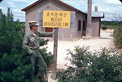
1956년 공동경비구역(JSA)의 MDL 표시.
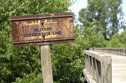
브리지 MDL 표지판.
컨텍스트에서 브리지 MDL 로그인.
JSA의 회의 건물 사이에 콘크리트 슬래브로 표시된 북쪽(왼쪽)과 남쪽(오른쪽) 사이의 MDL.
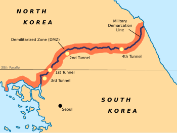
DMZ는 38선 근처에 있으며 대략 248km(154마일)에 걸쳐 있습니다.
미군 과 한국군은 한국측을 따라 이 선을 순찰하고, 북한군 은 북한측을 따라 순찰한다.
한국어 에서는 휴전선 (휴전선) 이라고 하는데 이는 "휴전선"을 의미합니다.
문자 그대로 "군사분계선"을 의미하는 군사분계선 이라고도 합니다 . 그러나 구어체에서는 이 경계선을 삼팔선 (삼팔선, " 38도선 ")이라고 부르는 경우가 더 많습니다.
이 이름은 제2차 세계대전 말에 만들어졌을 것으로 추정되며, 이는 남북 국경에 대한 정확한 설명이었을 것입니다. .
선 자체는 반도 전체에 일정한 간격을 두고 배치된 일련의 1,292개의 동일한 기호로 표시됩니다. 표지판의 북쪽 면에는 한국어와 중국어, 남쪽 면에는 한국어와 영어로 표시되어 있습니다.
이제 그 흔적은 노화되고 녹슬고 있습니다.
군사적 사건
휴전으로 한국전쟁 이 끝난 후로 이 전선을 따라 잦은 충돌이 있어 왔습니다 .
북방한계선
서해 에서 남북한 사이에 분쟁이 있는 해상 국경 : [
A: 유엔사령부가 1953년에 설정한 북방한계선
B: 북한이 선언한 '남북 MDL', 1999
특정 섬의 위치는 각 해상 경계선의 구성에 반영됩니다.
1. 연평도
2. 백령도
3. 대청도
주요 기사: 북방 한계선
이 부분의 본문은 한국 해상 국경 사건입니다.
한국 정전협정에는 육지에서 경계선 과 비무장지대가 어디에 위치하는지 명시하고 있지만, 인접한 해역 의 경계선이나 구역은 언급되어 있지 않습니다.
휴전협정이 체결된 직후 유엔군사령부(UNC)가 일방적으로 바다에 선을 그었다.
이 북방한계선(NLL)은 남북이 합의한 경계선이 아니라 남한 선박이 항해할 수 있는 북방한계선을 의미한다.
군사분계선(MDL)과 DMZ에 관한 한국정전협정(KAA) 조항은 황해나 일본해에는 적용되지 않는다.
1999년 북한은 일방적으로 '서해(황해) 북측 군사분계선', 즉 '서해 남북 군사분계선'이라고도 불리는 것을 주장 했다.
그럼에도 불구하고 유엔사가 그린 선은 간헐적인 침입과 충돌에도 불구하고 1953년 MDL의 사실상 또는 "실질적인" 확장 기능을 합니다.
공동경비구역(JSA) 통과
2018년 10월 16일, 남북한 정부는 인원이 비워지면 현지인과 관광객이 군사분계선의 악명 높은 공동경비구역(JSA)을 통과할 수 있도록 허용하기로 합의했습니다.
이번 횡단은 2018년 4월 27일 문재인 대통령 이 김정은 북한 국무 위원장 과 함께 북한에 들어간 짧은 순간과 유사할 것입니다.
공동합동 이후 2018년 10월 25일 보안구역에서 무장군인이 해제됨에 따라 군사분계선 건널목 관광이 지연된다고 발표되었다.
완충지대, 비행금지구역, 서해평화지대 설정
2018년 11월 1일, 한국 국방부 관계자는 남북한 군대가 군사분계선(MDL)으로부터 거리를 유지할 수 있도록 DMZ 전역에 완충지대를 설치했음을 확인했습니다.
2018년 9월 남북 정상회담 에서 체결된 포괄적 군사합의에 따라, 완충지대는 남북이 육지, 공중, 해상에서의 적대 행위를 금지하는 데 도움이 됩니다.
완충지대는 서해에서는 덕적도 북쪽부터 초도 남쪽까지, 동해에서는 속초시 북쪽, 동촌군 이남까지 뻗어 있다.
남북한 모두 군사분계선 5㎞ 이내에서 실사격 포병훈련과 연대급 야전기동훈련, 대형부대별 야전훈련 등을 금지하고 있다.
DMZ 주변에는 비행금지구역이 설정돼 군사분계선으로부터 최대 40km 떨어진 지역에서 드론, 헬기, 기타 항공기의 운항을 금지한다. 무인항공기의 비행금지구역은 동쪽의 군사분계선에서 15km, 서쪽의 군사분계선에서 10km 이다.
열기구의 경우 군사분계선으로부터 25㎞ 이내이다.
고정익 항공기의 경우, 동쪽의 군사분계선을 기준으로 40km 이내(MDL 표시번호 0646~1292 사이), 서쪽의 군사분계선을 기준으로 20km 이내(MDL 표시번호 0001 사이)를 비행금지구역으로 지정한다. 및 0646). 회전익 항공기의 경우 군사분계선(MDL) 10km 이내를 비행금지구역으로 지정한다.
두 개의 한국은 또한 MDL과 접하는 황해 지역에 "평화지대"를 설정했습니다.
MDL 교차로 재연결
2018년 11월 22일, 남북한은 DMZ를 따라 3km 도로를 연결하는 공사를 완료했습니다.
군사분계선을 가로지르는 도로는 남한 1.7km, 북한 1.3km이다.
DMZ 화살머리고지 지뢰 제거와 한국전 유해 발굴 작업을 지원하기 위해 14년 만에 도로가 연결됐다.
남북교통서비스
2018년 11월 30일, '전선' 감시초소와 화살머리고지 지뢰가 제거된 후, 한국 열차가 군사분계선을 넘어 북한으로 진입하면서 남북 철도 운송(2008년 11월 중단됨)이 재개되었습니다.
2018년 12월 8일, 남한의 버스 한 대가 군사분계선을 넘어 북한으로 향했다.
군사 국경 통과
2018년 12월 12일, 남북한 군대는 '전선' 초소 철거를 확인하기 위해 사상 처음으로 군사분계선을 넘어 반대국으로 진입했다.
2024년 6월 5일, 한국군 은 남북 군사합의가 중단된 이후 휴전선 내 모든 군사활동을 재개하겠다고 발표했다.
또한 보십시오
한국의 분단
판문점
캠프 보니파스
한국전쟁의 여파
독일 내부 국경
참고사항
군사분계선은 한국정전협정(KAA) 제1조 1~11항에 정의 및 확립되었습니다.
KAA에는 MDL 및 DMZ에 관한 조항이 포함되어 있습니다.
그러나 그러한 조항은 황해나 일본해에는 적용되지 않습니다.
2012년 3월 11일 웨이백 머신(Wayback Machine) 에 보관된 이후 고안된 북방경계선( NLL) 은 처음에는 군사분계선(MDL)의 일부로 간주되지 않았으며, 북한과 유엔사는 1953년에 합의한 한계를 넘어서는 후속 군사분계선 확장에 동의하지 않았습니다.
7/27.류무봉. (2009). "한국의 휴전과 섬들", 2013년 2월 21일에 보관됨 : Wayback Machine p. 5. 미 육군 전쟁대학 전략 연구 프로젝트 발췌, " 합의의 전략적 결과 . 5개 섬을 유엔사 통제하에 두기로 한 합의는 한반도 안보 환경의 여러 측면을 형성해 왔습니다.
가장 명백하고 눈에 띄는 결과는 북방한계선(NLL)의 설정입니다. NLL은 실질적인 해양 경계선이자 군대를 분리하여 남북한 간의 군사적 충돌을 방지하는 효과적인 수단으로 기능해 왔습니다.
김광태와 비교. "교전 이후 북한, 남한에 대한 추가 공격 위협", 2010년 11월 26일 Wayback Machine Time (미국)에 보관됨 . 2010년 11월 23일.
박희권. (2000).해양법과 동북아: 협력을 위한 도전, p. 108, Google Books ; "1953년 정전협정에 따라 한반도 전역에 군사분계선이 그어졌다. 그러나 정전협정에는 해상분계선이 명시되어 있지 않았기 때문에 유엔사령부가 NLL을 그었다...."
"한국전쟁사" . lifeinkorea.com . 2006년 1월 12일에 확인함 .
예를 들어 사전 – 휴전의 정의를 참조하세요. 2011년 6월 28일에 Wayback Machine 에 보관됨
북쪽에서 본 MDL 간판 (JPG)(국문). i.pinimg.com.
북한군이 초소 점검을 위해 국경을 넘고 있다 . 2018년 12월 13일 – www.youtube.com을 통해.
류무봉. (2009). "한국 휴전과 섬들", 2013년 2월 21일에 보관됨 , Wayback Machine p. 13 ( PDF-p. 21 ). 미 육군 전쟁대학 전략 연구 프로젝트; 2010년 11월 26일에 확인함.
"Factbox: 한국 북방한계선이란 무엇입니까?" 로이터(영국). 2010년 11월 23일; 2010년 11월 26일에 확인함.
반 다이크, 존 외. “황(서)해에서의 남북경계분쟁,” 해양정책 27(2003), 143–58; "남북 MDL"이 인용된 이유는 이 내용이 Wayback Machine 에 2012년 3월 9일 보관된 학술 자료 에서 나온 것이며 , 저자가 우리가 제시할 때 인용문을 포함할 만큼 충분히 구체적이었기 때문입니다. 더 넓은 의미는 여기서 해상 경계선이 군사분계선의 공식적인 연장이 아니라는 것입니다. 비교 "NLL—논쟁적인 남한과 북한의 해상 경계", 인민일보 (PRC), 2002년 11월 21일자; 2010년 12월 22일에 확인함
Glionna, John M. "해상 국경은 한반도 긴장의 방아쇠입니다", Los Angeles Times (미국). 2011년 1월 6일; 2011년 7월 28일에 확인함
김영구. "황해 해상 경계 분쟁: 대한민국," Archived 2011-07-13 at the Wayback Machine Journal of East Asia and International Law (JEAIL), Volume 2, Number 2.
"한국 해상 경계선의 현대적 의미," 한겨레 (ROK). 2007년 10월 15일.
원칙적으로 유엔사와 북한은MDL을 황해까지 확장하는 데 동의 할 수 있습니다 (IAW, KAA 62항). 그러나 그러한 합의는 없습니다.
Zou, Keyuan. (2005).동아시아 해양법: 과제와 전망, p. 7, Google 도서 에서 ; "일방적인 NLL에 대응하여 북한 당국은 1999년 사건(1999년 9월 2일) 이후 NLL과 겹치는 '서해(황해)에 북한 군사분계선'을 설정했다고 선언했다. 기존 NLL"; 이효상. (2001).북한: 이상한 사회주의 요새, p. 191 , p. 191, Google Books 에서 ; "대한민국은 원칙 없는 범죄자다." – 북한 [sic] 스리랑카 가디언, 2010년 11월 25일.
"NLL—남한, 북한 간 해상 국경 논란," 인민일보 (PRC), 2002-11-21; 2010년 11월 26일에 확인함.
류, p. 11; "NLL은 46년 동안 남북한 군대 사이의 군사적 긴장을 방지하는 효과적인 수단이자, 실질적인 분단선 역할을 하며, 군사분리에도 기여해 왔습니다." 1999년 유엔사령부(한국) ; 아이그너, 에린, 박해운. 뉴욕타임스, “남북한 해상에서의 군사공격” . 2010년 11월 23일; 윌리엄스, 데이비드, 피터 심슨. 2010년 12월 22일에 확인함.
리드비터, 크리스(2018년 10월 19일)."한국 DMZ에서의 셀카와 색다른 국경 여행 경험".전신.
"관광객들은 곧 남북한 사이의 DMZ를 걸어서 횡단할 수 있을 것입니다".Bloomberg.com.
"관광객들은 곧 세계에서 가장 긴장된 국경을 넘어 걸어갈 수 있게 될 것입니다" . 여행자 . 2018년 10월 18일.
"한국, 남북 국경 공동경비구역(JSA) 비무장화" . UPI .
"연합뉴스".
"역사적인 판문점 선언의 군사영역 이행에 관한 합의"(PDF).전국북한위원회. 피. 2.
"두 개의 한국이 군사 훈련을 종료하고 MDL 근처 비행금지구역 운영을 시작: MND". NK News – North Korea News. 2018년 11월 1일.
"(2LD) 중무장된 DMZ 내부 남북 연결도로" . 연합뉴스 . 2018년 11월 22일.
"남북은 DMZ를 통해 국경도로 연결".www.aa.com.tr.
"14년 만에 남북통일, 전사자 유해복구의 길" . www.asianews.it .
"북한, 14년 만에 도로 연결" . Reuters . 2018년 11월 23일. 2024년 2월 26일 원본 에서 보관됨 – Yahoo News를 통해 .
"14년 만에 남북이 길을 만난다" . 케언즈 포스트 .[ 영구적으로 끊어진 링크 ]
지안루카 아바니나(2018년 11월 30일). “10년 만에 첫 열차, 남한 출발 북한행” . 전신 .
"북 동부철도 합동점검 시작" . world.kbs.co.kr .
"사상 처음으로 군대가 남북 비무장지대를 평화롭게 통과합니다" . www.cbsnews.com . 2018년 12월 12일.
"남북군이 서로의 영토에 침입하다 - 북한이 남침하다" . 경제 타임즈 . 2018년 12월 16일에 원본 문서 에서 보존된 문서 . 2018년 12월 12일에 확인함 .
"한국, 휴전선 일대 모든 군사활동 재개" . 로이터 . 2024년 6월 4일 . 2024년 6월 5일에 확인함 .
참고문헌
이효상. (2001). 북한: 이상한 사회주의 요새. 코네티컷주 웨스트포트: 프레거. ISBN 978-0275969172 ; OCLC 237388400
박희권. (2000). 해양법과 동북아: 협력을 위한 도전. 보스턴: Kluwer Law International. ISBN 978-9041114075 ; OCLC 154667938
반 다이크, 존 M., 마크 J. 발렌시아, 제니 밀러 가르멘디아. "황(서)해에서의 남북한 경계 분쟁," . 해양 정책 27(2003), 143–158.
Zou, Keyuan Zou. (2005). 동아시아해양법: 과제와 전망. 런던: 루트리지. ISBN 0-415-35074-3 ; OCLC 55960798
V티이자형
북한의 국경
중국러시아대한민국 한국 비무장지대군사분계선북방한계선
카테고리 :한국 비무장지대북한-남한 국경한국전쟁의 여파국경
--------------------------------------------------------------------------------------------------
Military Demarcation Line
| Military Demarcation Line | |
|
군사분계선 / 휴전선
|
|
|
軍事分界線 / 休戰線
|
|
| Gunsabungyeseon / Hyujeonseon | |
| Kunsabungyesŏn / Hyujŏnsŏn | |
The Military Demarcation Line (MDL), sometimes referred to as the Armistice Line, is the land border or demarcation line between North Korea and South Korea. On either side of the line is the Korean Demilitarized Zone (DMZ). The MDL and DMZ were established by the Korean Armistice Agreement.[1]
In the Yellow Sea, the two Koreas are divided by a de facto maritime "military demarcation line" and maritime boundary called the Northern Limit Line (NLL) drawn by the United Nations Command in 1953.[2] The NLL is not described by the Korean Armistice Agreement.[3]
Demarcation on land[edit]

The DMZ runs near the 38th parallel, covering roughly 248 kilometers (154 mi).[4] American and South Korean soldiers patrol this line along the South Korean side while North Korean soldiers patrol along the North Korean side.
In Korean, the line is called the Hyujeonseon (휴전선), meaning "armistice line."[5] It is also sometimes called the Gunsa Bungye-seon (군사분계선), which literally means "military demarcation line." However, in colloquial usage, the dividing line is more often called the Sampalseon (삼팔선, "38th parallel"), a name likely coined at the end of World War II, when it would have been an accurate description of the North-South border.
The line itself is marked off by a series of 1,292 identical signs which are placed at intervals across the peninsula. The north facing side of the signs are written in Korean and Chinese,[6] and in Korean and English on the south facing side. The signs are now aging and rusting.[7]
Military incidents[edit]
There have been frequent skirmishes along the line since the armistice ended the fighting of the Korean War.
Northern Limit Line[edit]
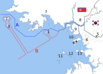
B: North Korea-declared "Inter-Korean MDL", 1999[10]
The locations of specific islands are reflected in the configuration of each maritime boundary, including
1. Yeonpyeong Island
2. Baengnyeong Island
3. Daecheong Island
Although the Korean Armistice Agreement specifies where the demarcation line and demilitarized zone are located on land, the agreement does not mention lines or zones in adjacent ocean waters.[11] Shortly after the signing of the Armistice, a line in the sea was drawn unilaterally by the United Nations Command (UNC).[12] This Northern Limit Line or North Limit Line (NLL) represented the northern limit of the area in which South Korea permits its vessels to navigate, not a demarcation line on which the two Koreas agreed.[13] The Korean Armistice Agreement (KAA) provisions regarding the MDL and DMZ do not extend into the Yellow Sea or Sea of Japan.[14]
In 1999, North Korea unilaterally asserted its own "North Korean Military Demarcation Line in the West Sea (Yellow Sea)",[15] also called the "Inter-Korean MDL in the Yellow Sea".[16]
Nonetheless, the UNC-drawn line functions as a de facto or "practical" extension of the 1953 MDL, despite occasional incursions and clashes.[17]
Joint Security Area crossing[edit]
On October 16, 2018, the governments of North and South Korea agreed to allow locals and tourists to cross the Military Demarcation Line's infamous Joint Security Area location once it is cleared of personnel.[18][19][20] The crossings will resemble the brief moment South Korean President Moon Jae-in stepped into North Korea with North Korean Chairman Kim Jong-un on April 27, 2018.[18][19] After the Joint Security Area was cleared of armed military personnel on October 25, 2018, it was announced that tourism at the MDL crossing would be delayed.[21]
Establishment of buffer zones, no-fly zones and Yellow Sea peace zones[edit]
On November 1, 2018, officials from the South Korean Ministry of Defense confirmed that buffer zones were established across the DMZ by the North and South Korean militaries to ensure that both militaries would keep their distance from the Military Demarcation Line (MDL).[22] In compliance with the Comprehensive Military Agreement which was signed at the September 2018 inter-Korean summit,[23] the buffer zones help ensure that both Koreas will ban hostility on land, air and sea.[22] The buffer zones stretch from the north of Deokjeok Island to the south of Cho Island in the West Sea and the north of Sokcho city and south of Tongchon County in the East (Yellow) Sea.[24] Both North and South Korea are prohibited from conducting live-fire artillery drills and regiment-level field maneuvering exercises or those by bigger units within 5 kilometers of the MDL.[22][23][24]
No-fly zones have also been established along the DMZ to ban the operation of drones, helicopters and other aircraft over an area up to 40 km away from the MDL.[22][23] For UAVs, the no-fly zone is 15 km from the MDL in the East and 10 km from the MDL in the West.[23] For hot-air balloons, the zone is within 25 km from the MDL.[23] For fixed-wing aircraft, no fly zones are designated within 40 km from the MDL in the East (between MDL Markers No. 0646 and 1292) and within 20 km of the MDL in the West (between MDL Markers No. 0001 and 0646).[23] For rotary-wing aircraft, the no fly zones are designated within 10 km of the MDL.[23]
Both Koreas also established "peace zones" in the area of the Yellow Sea which borders the MDL as well.[22][23]
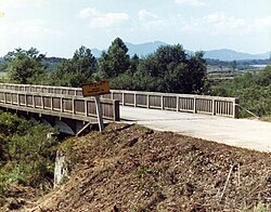
Reconnecting of MDL-crossing road[edit]
On November 22, 2018, North and South Korea completed construction to connect a three kilometer road along the DMZ.[25][26] The road, which travels across the MDL, has 1.7 km in South Korea and 1.3 km in North Korea.[26] The road was reconnected for the first time in 14 years in an effort to assist with a process at the DMZ's Arrowhead Hill involving the removal of landmines and exhumation of Korean War remains.[27][28][29]
Inter-Korean transportation services[edit]
On November 30, 2018, following the removal of the "frontline" guard posts and Arrowhead Hill landmines, rail transportation between North and South Korea (which ceased in November 2008) resumed when a South Korean train crossed the MDL into North Korea.[30] On December 8, 2018, a South Korean bus crossed the MDL into North Korea.[31]
Military border crossing[edit]
On December 12, 2018, militaries from both Koreas crossed the MDL into the opposition countries for the first time in history to verify the removal of "frontline" guard posts.[32][33]
On June 5 2024 South Korea's military announced that it would resume all military activity on the demarcation line after the suspension of an inter-Korean military agreement.[34]
See also[edit]
Notes[edit]
- ^ The MDL was defined and established in the Korean Armistice Agreement (KAA), Article I, paragraphs 1–11. The KAA includes provisions regarding the MDL and DMZ; but those provisions do not extend into the Yellow Sea or the Sea of Japan. The subsequently devised Northern Boundary Line or NLL Archived 2012-03-11 at the Wayback Machine was neither initially conceived as part of the MDL, nor have the DPRK and UNC agreed to any subsequent extension of the MDL beyond the agreed upon limits of 1953/7/27.
- ^ Ryoo, Moo Bong. (2009). "The Korean Armistice and the Islands," Archived 2013-02-21 at the Wayback Machine p. 5. Strategy research project at the U.S. Army War College; excerpt, "Strategic Consequences of the Agreement. The agreement to retain the five islands under UNC control has shaped many aspects of the security environment of the Korean Peninsula. The most obvious and prominent consequence is the establishment of the Northern Limit Line (NLL). The NLL has served as a practical maritime borderline and an effective means to separate the forces and thus prevent military clashes between the two Koreas"; compare Kim, Kwang-Tae. "After Exchange of Fire, N. Korea Threatens More Strikes on South," Archived 2010-11-26 at the Wayback Machine Time (US). November 23, 2010.
- ^ Pak, Hŭi-gwŏn. (2000). The Law of the Sea and Northeast Asia: a Challenge for Cooperation, , p. 108, at Google Books; excerpt, "Under the 1953 Armistice Agreement, the Military Demarcation Line was drawn across the Korean peninsula. Since no maritime demarcation line was specified in the Armistice Agreement, however, the United Nations Command drew the NLL...."
- ^ "Korean War History". lifeinkorea.com. Retrieved 12 January 2006.
- ^ See, e.g., Dictionary – Definition of armistice. Archived 2011-06-28 at the Wayback Machine
- ^ MDL sign seen from the North (JPG) (in Korean). i.pinimg.com.
- ^ North Korean troops cross the border for guard post inspections. 13 December 2018 – via www.youtube.com.
- ^ Ryoo, Moo Bong. (2009). "The Korean Armistice and the Islands," Archived 2013-02-21 at the Wayback Machine p. 13 (at PDF-p. 21 ). Strategy research project at the U.S. Army War College; retrieved 26 Nov 2010.
- ^ "Factbox: What is the Korean Northern Limit Line?" Reuters (UK). November 23, 2010; retrieved 26 Nov 2010.
- ^ Van Dyke, Jon et al. "The North/South Korea Boundary Dispute in the Yellow (West) Sea," Marine Policy 27 (2003), 143–58; note that "Inter-Korean MDL" is cited because it comes from an academic source Archived 2012-03-09 at the Wayback Machine and the writers were particular enough to include in quotes as we present it. The broader point is that the maritime demarcation line here is NOT a formal extension of the Military Demarcation Line; compare "NLL—Controversial Sea Border Between S.Korea, DPRK, " People's Daily (PRC), November 21, 2002; retrieved 22 Dec 2010
- ^ Glionna, John M. "Sea border a trigger for Korean peninsula tension," Los Angeles Times (US). January 6, 2011; retrieved 2011-07-28
- ^ Kim Young-koo. "A Maritime Demarcation Dispute on the Yellow Sea: Republic of Korea," Archived 2011-07-13 at the Wayback Machine Journal of East Asia and International Law (JEAIL), Volume 2, Number 2.
- ^ "Modern meaning of Korea's maritime line," The Hankyoreh (ROK). October 15, 2007.
- ^ In principle, the UNC and DPRK could agree to extend the MDL into the Yellow Sea (IAW para. 62 of the KAA); however, there is no such agreement.
- ^ Zou, Keyuan. (2005). Law of the Sea in East Asia: Issues and Prospects, , p. 7, at Google Books; excerpt, "In response to the unilateral NLL, the North Korean authorities declared after the 1999 incident (on 2 September 1999), that they had set up a 'North Korean Military Demarcation Line in the West Sea (Yellow Sea)' which overlaps with the existing NLL"; Lee, Hy-Sang Lee. (2001). North Korea: a Strange Socialist Fortress, p. 191, p. 191, at Google Books; "South Korea is a criminal without principle." – Noth Korea [sic] Sri Lanka Guardian, November 25, 2010.
- ^ "NLL—Controversial Sea Border Between S.Korea, DPRK, " People's Daily (PRC), 2002-11-21; retrieved 2010-11-26.
- ^ Ryoo, p. 11; excerpt, "The NLL has served as an effective means of preventing military tension between North and South Korean military forces for 46 years. It serves as a practical demarcation line, which has contributed to the separation of forces." 1999 United Nations Command (Korea); Aigner, Erin and Haeoun Park. "Military Strike in the Waters Between North and South Korea," New York Times. November 23, 2010; Williams, David and Peter Simpson. retrieved 22 Dec 2010.
- ^ Jump up to:a b Leadbeater, Chris (19 October 2018). "Selfies in the Korean DMZ – and other unusual border travel experiences". The Telegraph.
- ^ Jump up to:a b "Tourists May Soon Get to Walk Across the DMZ Between North and South Korea". Bloomberg.com.
- ^ "Tourists will soon be allowed to walk across the world's tensest border". Traveller. 18 October 2018.
- ^ "South Korea disarms Joint Security Area in North-South border". UPI.
- ^ Jump up to:a b c d e "Yonhap News Agency".
- ^ Jump up to:a b c d e f g h "Agreement on the Implementation of the Historic Panmunjom Declaration in the Military Domain" (PDF). The National Committee on North Korea. p. 2.
- ^ Jump up to:a b "Two Koreas end military drills, begin operation of no-fly zone near MDL: MND". NK News – North Korea News. 1 November 2018.
- ^ "(2nd LD) Koreas connect road inside heavily fortified DMZ". Yonhap News Agency. 22 November 2018.
- ^ Jump up to:a b "South, North Korea connect border road through DMZ". www.aa.com.tr.
- ^ "After 14 years, a road to unite the Koreas and recover the remains of the fallen". www.asianews.it.
- ^ "North and South Korea join roads after 14 years". Reuters. 23 November 2018. Archived from the original on 26 February 2024 – via Yahoo News.
- ^ "North and South Korea join roads after 14 years". The Cairns Post.[permanent dead link]
- ^ Avagnina, Gianluca (30 November 2018). "First train in a decade departs South Korea for North Korea". The Telegraph.
- ^ "Joint Inspection of N. Korea's Eastern Rail Line Begins". world.kbs.co.kr.
- ^ "Troops cross North-South Korea Demilitarized Zone in peace for 1st time ever". www.cbsnews.com. 12 December 2018.
- ^ "North and South Korean soldiers enter each other's territory – North invades the South". The Economic Times. Archived from the original on 16 December 2018. Retrieved 12 December 2018.
- ^ "South Korea to resume all military activities along demarcation line". Reuters. 4 June 2024. Retrieved 5 June 2024.
References[edit]
- Lee, Hy-Sang Lee. (2001). North Korea: a Strange Socialist Fortress. Westport, Connecticut: Praeger. ISBN 978-0275969172; OCLC 237388400
- Pak, Hŭi-gwŏn. (2000). The Law of the Sea and Northeast Asia: a Challenge for Cooperation. Boston: Kluwer Law International. ISBN 978-9041114075; OCLC 154667938
- Van Dyke, Jon M., Mark J. Valencia and Jenny Miller Garmendia. "The North/South Korea Boundary Dispute in the Yellow (West) Sea," . Marine Policy 27 (2003), 143–158.
- Zou, Keyuan Zou. (2005). Law of the Sea in East Asia: Issues and Prospects. London: Routledge. ISBN 0-415-35074-3; OCLC 55960798
'■ 大韓民國 > KOREA' 카테고리의 다른 글
| 유인촌 장관 "세계서 한국문화 위상 실감…문화는 산업, 더 투자해야" (0) | 2024.07.27 |
|---|---|
| 오세훈 시장, '광화문 대형 태극기 게양' 논란에 "귀 더 열겠다" (0) | 2024.07.01 |
| 삼바 댄스로 물들인 명동거리, 롯데월드 '시티 바캉스&삼바' (0) | 2024.06.20 |
| 청색 한복 입은 브라질 예수상 (0) | 2024.06.10 |
| 한일중 회담 (0) | 2024.05.27 |