■ CANADA

2022. 9. 10. 09:58■ 국제/CANADA


■ 13 Province, CANADA

-------------------------------------------------

■  Alberta

Jump to navigationJump to search
This article is about the Canadian province. For other uses, see Alberta (disambiguation).
AlbertaCountryConfederationCapitalLargest cityLargest metroGovernment • Type • Lieutenant governor • PremierLegislatureFederal representationHouse seatsSenate seatsArea • Total • Land • Water • Rank Population (2021) • Total • Estimate (Q2 2022) • Rank • DensityDemonymOfficial languagesGDP • Rank • Total (2015) • Per capitaHDI • HDI (2019)Time zone • Summer (DST)Canadian postal abbr.Postal code prefixISO 3166 codeFlowerTreeBird
 
Motto(s): 
Fortis et liber  (Latin)
("Strong and free")
Coordinates: 55°59′30″N 114°22′36″W[1]Coordinates: 55°59′30″N 114°22′36″W[1]
Canada
September 1, 1905; 117 years ago (split from NWT) (10th, with Saskatchewan)
Edmonton
Calgary
Calgary Region
Parliamentary constitutional monarchy
Salma Lakhani
Jason Kenney
Legislative Assembly of Alberta
Parliament of Canada
34 of 338 (10.1%)
6 of 105 (5.7%)
661,848 km2 (255,541 sq mi)
640,081 km2 (247,137 sq mi)
19,531 km2 (7,541 sq mi)  3%
6th
6.6% of Canada
4,262,635 [2]
4,500,917 [3]
4th
6.66/km2 (17.2/sq mi)
Albertan
English[4][5]
3rd
CA$326.433 billion[6]
CA$78,100 (2nd)
0.948[7]  Very high (1st)
UTC−07:00 (Mountain)
UTC−06:00 (Mountain DST)
AB
CA-AB
Wild rose
Lodgepole pine
Great horned owl
Rankings include all provinces and territories


Alberta (/ælˈbɜːrtə/ al-BER-tə) is one of the thirteen provinces and territories of Canada. It is part of Western Canada and is one of the three prairie provinces. Alberta is bordered by British Columbia to the west, Saskatchewan to the east, the Northwest Territories (NWT) to the north, and the U.S. state of Montana to the south. It is one of the only two landlocked provinces in Canada (Saskatchewan being the other).[8] The eastern part of the province is occupied by the Great Plains, while the western part borders the Rocky Mountains. The province has a predominantly continental climate but experiences quick temperature changes due to air aridity. Seasonal temperature swings are less pronounced in western Alberta due to occasional chinook winds.[9]

Alberta is the 4th largest province by area at 661,848 km2 (255,541 sq mi),[10] and the 4th most populous, being home to 4,262,635 people.[2] Alberta's capital is Edmonton, while Calgary is its largest city.[11] The two are Alberta's largest census metropolitan areas.[12] More than half of Albertans live in either Edmonton or Calgary, which contributes to continuing the rivalry between the two cities. English is the official language of the province. In 2016, 76.0% of Albertans were anglophone, 1.8% were francophone and 22.2% were allophone.[13]

Alberta's economy is based on hydrocarbons, petrochemical industries, livestock and agriculture.[14] The oil and gas industry has been a pillar of Alberta's economy since 1947, when substantial oil deposits were discovered at Leduc No. 1 well.[15] It has also become a part of the province's identity. Since Alberta is the province most rich in hydrocarbons, it provides 70% of the oil and natural gas exploited on Canadian soil. In 2018, Alberta's output was CA$338.2 billion, 15.27% of Canada's GDP.[16][17]

In the past, Alberta's political landscape hosted parties like the centre-left Liberals and the agrarian United Farmers of Alberta. Today, Alberta is generally perceived as a conservative province. The right-wing Social Credit Party held office continually from 1935 to 1971 before the centre-right Progressive Conservatives held office continually from 1971 to 2015, the latter being the longest unbroken run in government at the provincial or federal level in Canadian history.

Before becoming part of Canada, Alberta was home to several First Nations like Plain Indians and Woodland Cree. It was also a territory used by fur traders of the rival companies HBC and NWC. The Dominion of Canada bought the lands that would become Alberta as part of the NWT in 1870.[18] From the late 1800s to early 1900s, many immigrants arrived to prevent the prairies from being annexed by the US. Growing wheat and cattle ranching also became very profitable. In 1905, the Alberta Act was passed, creating the province of Alberta.[19] Massive oil reserves were discovered in 1947. The exploitation of oil sands began in 1967.[15]

Alberta is renowned for its natural beauty, richness in fossils and for housing important nature reserves. Alberta is home to six UNESCO designated World Heritage Sites: The Canadian Rocky Mountain Parks, Dinosaur Provincial Park, the Head-Smashed-In Buffalo Jump, Waterton-Glacier International Peace Park, Wood Buffalo National Park and Writing-on-Stone Provincial Park.[20] Other popular sites include Banff National Park, Elk Island National Park, Jasper National Park, Waterton Lakes National Park, and Drumheller.

Alberta

-------------------------------------------------

British Columbia

Jump to navigationJump to search
British ColumbiaCountryConfederationCapitalLargest cityLargest metroGovernment • Type • Lieutenant governor • PremierLegislatureFederal representationHouse seatsSenate seatsArea • Total • Land • Water • Rank Population (2021) • Total • Estimate (Q2 2022) • Rank • DensityDemonymOfficial languagesGDP • Rank • Total (2015) • Per capitaHDI • HDI (2019)Time zonesMost of province[b] • Summer (DST)Southeastern • Summer (DST)EasternCanadian postal abbr.Postal code prefixISO 3166 codeFlowerTreeBird
Mottoes: 
  • Splendor Sine Occasu  (Latin)
  • English: Splendour without diminishment
Coordinates: 54°N 125°W[1]Coordinates: 54°N 125°W[1]
Canada
July 20, 1871 (6th)
Victoria
Vancouver
Greater Vancouver
Parliamentary constitutional monarchy
Janet Austin
John Horgan
Legislative Assembly of British Columbia
Parliament of Canada
42 of 338 (12.4%)
6 of 105 (5.7%)
944,735 km2 (364,764 sq mi)
925,186 km2 (357,216 sq mi)
19,548.9 km2 (7,547.9 sq mi)  2.1%
5th
9.5% of Canada
5,000,879 [2]
5,286,528  [3]
3rd
5.41/km2 (14.0/sq mi)
British Columbian[a]
English (de facto)
4th
CA$249.981 billion[4]
CA$53,267 (8th)
0.938[5]  Very high (2nd)
UTC−08:00 (Pacific)
UTC−07:00 (Pacific DST)
UTC−07:00 (Mountain)
UTC−06:00 (Mountain DST)
UTC−07:00 (Mountain [no DST])
BC
CA-BC
Pacific dogwood
Western red cedar
Steller's jay
Rankings include all provinces and territories


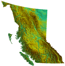
British Columbia (BC; French: Colombie-Britannique) is the westernmost province of Canada, situated between the Pacific Ocean and the Rocky Mountains. It has a diverse geography, with rugged landscapes that include rocky coastlines, sandy beaches, forests, lakes, mountains, inland deserts and grassy plains,[6] and borders the province of Alberta to the east and the Yukon and Northwest Territories to the north. With an estimated population of 5.3 million as of 2022, it is Canada's third-most populous province.[7] The capital of British Columbia is Victoria and its largest city is Vancouver. Vancouver is the third-largest metropolitan area in Canada; the 2021 census recorded 2.6 million people in Metro Vancouver.[8]

The first known human inhabitants of the area settled in British Columbia at least 10,000 years ago. Such groups include the Coast Salish, Tsilhqotʼin, and Haida peoples, among many others. One of the earliest British settlements in the area was Fort Victoria, established in 1843, which gave rise to the city of Victoria, the capital of the Colony of Vancouver Island. The Colony of British Columbia (1858–1866) was subsequently founded by Richard Clement Moody,[9] and by the Royal Engineers, Columbia Detachment, in response to the Fraser Canyon Gold Rush. Moody selected the site for and founded the mainland colony's capital New Westminster.[10][11][12] The colonies of Vancouver Island and British Columbia were incorporated in 1866, subsequent to which Victoria became the united colony's capital. In 1871, British Columbia entered Confederation as the sixth province of Canada, in enactment of the British Columbia Terms of Union.

British Columbia is a diverse and cosmopolitan province, drawing on a plethora of cultural influences from its British, European, and Asian diasporas, as well as the Indigenous population. Though the province's ethnic majority originates from the British Isles, many British Columbians also trace their ancestors in continental Europe, China, and South Asia.[13] Indigenous Canadians constitute about 5 percent of the province's total population. Christianity is the most subscribed religion, although the number of British Columbians who claim no religious affiliation whatsoever is high by Canadian standards.[14] English is the common language of the province, although Punjabi, Mandarin Chinese, and Cantonese also have a large presence in the Metro Vancouver region. The Franco-Columbian community is an officially recognized linguistic minority, and around one percent of British Columbians claim French as their mother tongue.[15] British Columbia is home to at least 34 distinct Indigenous languages.[16]

Major sectors of British Columbia's economy include forestry, mining, filmmaking and video production, tourism, real estate, construction, wholesale, and retail. Its main exports include lumber and timber, pulp and paper products, copper, coal, and natural gas.[17] British Columbia exhibits high property values and is a significant centre for maritime trade:[18] the Port of Vancouver is the largest port in Canada and the most diversified port in North America.[19] Although less than 5 percent of the province's territory is arable land, significant agriculture exists in the Fraser Valley and Okanagan due to the warmer climate.[20] British Columbia is the fourth-largest province or territory by GDP.[21] British Columbia is home to 45% of all publicly listed companies in Canada.[22]

BC

-------------------------------------------------

■ Manitoba

Jump to navigationJump to search
This article is about the Canadian province. For other uses, see Manitoba (disambiguation).
ManitobaCountryConfederationCapital(and largest city)Largest metroGovernment • Type • Lieutenant Governor • PremierLegislatureFederal representationHouse seatsSenate seatsArea • Total • Land • Water • Rank Population (2021) • Total • Estimate (Q2 2022) • RankDemonymOfficial languagesGDP • Rank • Total (2015) • Per capitaTime zone • Summer (DST)
Motto(s): 
Latin: Gloriosus et Liber
"Glorious and free"
"Glorieux et libre"  (French)
Coordinates: 55°N 97°W[1]Coordinates: 55°N 97°W[1]
Canada
15 July 1870 (5th, with Northwest Territories)
Winnipeg
Winnipeg Region
Parliamentary constitutional monarchy
Janice Filmon
Heather Stefanson
Legislative Assembly of Manitoba
Parliament of Canada
14 of 338 (4.1%)
6 of 105 (5.7%)
649,950 km2 (250,950 sq mi)
548,360 km2 (211,720 sq mi)
101,593 km2 (39,225 sq mi)  15.6%
8th
6.5% of Canada
1,342,153[2]
1,393,179 [3]
5th
Manitoban
English[4]
6th
C$65.862 billion[5]
C$50,820 (9th)
UTC−06:00 (Central)
UTC−05:00 (Central DST)
Rankings include all provinces and territories


Manitoba (/ˌmænɪˈtbə/ (

listen) MAN-ih-TOH-bə) is a province of Canada at the longitudinal centre of the country. It is Canada's fifth-most populous province, with a population of 1,342,153 as of 2021,[2] of widely varied landscape, from arctic tundra and the Hudson Bay coastline in the north to dense boreal forest, large freshwater lakes, and prairie grassland in the central and southern regions.

Indigenous peoples have inhabited what is now Manitoba for thousands of years. In the early 17th century, British and French fur traders began arriving in the area and establishing settlements. The Kingdom of England secured control of the region in 1673 and created a territory named Rupert's Land, which was placed under the administration of the Hudson's Bay Company. Rupert's Land, which included all of present-day Manitoba, grew and evolved from 1673 until 1869 with significant settlements of Indigenous and Métis people in the Red River Colony. In 1869, negotiations with the Government of Canada for the creation of the province of Manitoba commenced. During the negotiations, several factors led to an armed uprising of the Métis people against the Government of Canada, a conflict known as the Red River Rebellion. The resolution of the conflict and further negotiations led to Manitoba becoming the fifth province to join Canadian Confederation, when the Parliament of Canada passed the Manitoba Act on July 15, 1870.

Manitoba's capital and largest city is Winnipeg, the seventh most populous municipality in Canada. Winnipeg is the seat of government, home to the Legislative Assembly of Manitoba and the Provincial Court. Four of the province's five universities, all four of its professional sports teams, and most of its cultural activities (including Festival du Voyageur and Folklorama) are located in Winnipeg. The city has train and bus stations and an international airport; a Canadian Forces base, CFB Winnipeg, operates from the airport and is the regional headquarters of the North American Aerospace Defense Command.

Manitoba

-------------------------------------------------

■ New Brunswick

Jump to navigationJump to search
This article is about the Canadian province. For the city in New Jersey, see New Brunswick, New Jersey. For other uses, see New Brunswick (disambiguation).
New BrunswickCountryConfederationCapitalLargest cityLargest metroGovernment • Type • Lieutenant Governor • PremierLegislatureFederal representationHouse seatsSenate seatsArea • Total • Land • Water • Rank Population (2021) • Total • Estimate (Q2 2022) • Rank • DensityDemonymsOfficial languagesGDP • Rank • Total (2017) • Per capitaHDI • HDI (2019)Time zone • Summer (DST)Canadian postal abbr.Postal code prefixISO 3166 codeFlowerTreeBird
Motto(s): 
Spem reduxit  (Latin)[1]
("Hope restored")
Coordinates: 46°30′N 66°00′W[2]Coordinates: 46°30′N 66°00′W[2]
Canada
1 July 1867 (1st, with Nova Scotia, Ontario, Quebec)
Fredericton
Moncton
Greater Moncton
Parliamentary constitutional monarchy
Brenda Murphy
Blaine Higgs
Legislative Assembly of New Brunswick
Parliament of Canada
10 of 338 (3%)
10 of 105 (9.5%)
72,907 km2 (28,150 sq mi)
71,450 km2 (27,590 sq mi)
1,458 km2 (563 sq mi)  2%
11th
0.7% of Canada
775,610 [3]
800,243 [4]
8th
10.86/km2 (28.1/sq mi)
New Brunswicker
FR: Néo-Brunswickois(e)
[5]
9th
C$36.088 billion[6]
C$42,606 (11th)
0.898[7]  Very high (12th)
UTC-04:00 (Atlantic)
UTC-03:00 (Atlantic DST)
NB
CA-NB
Purple violet
Balsam fir
Black-capped chickadee
Rankings include all provinces and territories


New Brunswick (French: Nouveau-Brunswick, pronounced [nuvo bʁœnswik], locally [nuvo bʁɔnzwɪk]) is one of the ten provinces (and three territories) of Canada. It is one of the three Maritime provinces and one of the four Atlantic provinces. It is the only province with both English and French as its official languages.

New Brunswick is bordered by Quebec to the north, Nova Scotia to the east, the Gulf of Saint Lawrence to the northeast, the Bay of Fundy to the southeast, and the U.S. state of Maine to the west. New Brunswick is about 83% forested and its northern half is occupied by the Appalachians.[8] The province's climate is continental with snowy winters and temperate summers.

New Brunswick has a surface area of 72,908 km2 (28,150 sq mi) and 775,610 inhabitants (2021 census).[9] Atypically for Canada, only about half of the population lives in urban areas. New Brunswick's largest cities are Moncton and Saint John, while its capital is Fredericton.

In 1969, New Brunswick passed the Official Languages Act which began recognizing French as an official language, along with English.[10] New Brunswickers have the right to receive provincial government services in the official language of their choice.[11] About 23 of the population are anglophone and 13 are francophone. New Brunswick is home to most of the cultural region of Acadia and most Acadians. New Brunswick's variety of French is called Acadian French and 7 regional accents can be found.[12]

New Brunswick was first inhabited by First Nations like the Miꞌkmaq and Maliseet. In 1604, Acadia, the first New France colony, was founded with the creation of Port-Royal. For 150 years afterwards, Acadia changed hands a few times due to numerous conflicts between France and the United Kingdom. From 1755 to 1764, the British deported Acadians en masse, an event known as the Great Upheaval. This, along with the Treaty of Paris, solidified Acadia as British property. In 1784, following the arrival of many loyalists fleeing the American Revolution, the colony of New Brunswick was officially created, separating it from what is now Nova Scotia.[13] In the early 1800s, New Brunswick prospered and the population grew rapidly. In 1867, New Brunswick decided to confederate with Nova Scotia and the Province of Canada (now Quebec and Ontario) to form Canada. After Confederation, shipbuilding and lumbering declined, and protectionism disrupted trade with New England.

From the mid-1900s onwards, New Brunswick was one of the poorest regions of Canada, a fact eventually mitigated by transfer payments. However, the province has seen the highest eastward migration in 45 years in both rural and urban areas, as people living in Ontario and other parts of Canada migrate to the area.[14] As of 2002, the provincial GDP was derived as follows: services (about half being government services and public administration) 43%; construction, manufacturing, and utilities 24%; real estate rental 12%; wholesale and retail 11%; agriculture, forestry, fishing, hunting, mining, oil and gas extraction 5%; transportation and warehousing 5%.[15] A powerful corporate concentration of large companies in New Brunswick, including most newspapers, are owned by the Irving Group of Companies.[16][17] The province's 2019 output was CA$38.236 billion, which is 1.65% of Canada's GDP.[18]

Tourism accounts for 9% of the labour force either directly or indirectly. Popular destinations include the Hopewell Rocks, Fundy National Park, Magnetic Hill, Kouchibouguac National Park and Roosevelt Campobello International Park.[19]

NB

-------------------------------------------------

■ Newfoundland and Labrador

Jump to navigationJump to search
"Newfoundland" redirects here. For the island, see Newfoundland (island). For other uses, see Newfoundland (disambiguation).
 
This article may require copy editing for reasons outlined at Talk:Newfoundland and Labrador#Some room for improvement. You can assist by editing it. (April 2022) (Learn how and when to remove this template message)
Newfoundland and LabradorCountryConfederationCapital(and largest city)Largest metroGovernment • Type • Lieutenant governor • PremierLegislatureFederal representationHouse seatsSenate seatsArea • Total • Land • Water • Rank Population (2021) • Total • Estimate (Q2 2022) • Rank • DensityDemonym(s)Official languagesGDP • Rank • Total (2011) • Per capitaHDI • HDI (2019)Time zonesNewfoundlandLabrador (Black Tickle and North)Canadian postal abbr.Postal code prefixISO 3166 codeFlowerTreeBird
Motto(s): 
Quaerite prime regnum Dei  (Latin)
"Seek ye first the kingdom of God" (Matthew 6:33)
Coordinates: 53°13′48″N 59°59′57″W[1]ACPVYCoordinates: 53°13′48″N 59°59′57″W[1]ACPVY
Canada
March 31, 1949 (12th)
St. John's
Greater St. John's
Parliamentary constitutional monarchy
Judy Foote
Andrew Furey
Newfoundland and Labrador House of Assembly
Parliament of Canada
7 of 338 (2.1%)
6 of 105 (5.7%)
405,720 km2 (156,650 sq mi)
373,872 km2 (144,353 sq mi)
31,340 km2 (12,100 sq mi)  7.7%
10th
4.1% of Canada
510,550 [2]
522,875 [3]
9th
1.37/km2 (3.5/sq mi)
Newfoundlander
Labradorian
(see notes)[a]
English (de facto)[4]
8th
C$33.624 billion[5]
C$65,556 (5th)
0.894[6]  Very high (13th)
UTC-03:30 (Newfoundland Time Zone)
UTC-04:00 (Atlantic Time Zone)
NL (formerly NF)
CA-NL
Pitcher plant
Black spruce
Atlantic puffin
Rankings include all provinces and territories


Newfoundland and Labrador (/njfənˈlænd  ... læbrəˈdɔːr/; frequently abbreviated as NL) is the easternmost province of Canada, in the country's Atlantic region. It is made up of the island of Newfoundland and the continental region of Labrador, having a total size of 405,212 square kilometres (156,500 sq mi). The province's population was expected to be 521,758 in 2021.[7] The island of Newfoundland (and its neighbouring smaller islands) is home to around 94 per cent of the province's population, with more than half residing in the Avalon Peninsula.

In the 2016 census, 97.0 per cent of people reported English (Newfoundland English) as their mother tongue, making it Canada's most linguistically homogeneous province.

Newfoundland was once home to the distinct varieties of Newfoundland French and Newfoundland Irish, as well as the now-extinct Beothuk language. The indigenous languages, Innu-aimun and Inuktitut, are also spoken in Labrador.

St. John's, the capital and largest city of Newfoundland and Labrador, is Canada's 20th-largest census metropolitan area and home to about 40% of the province's population. St. John's is the seat of government, housing the House of Assembly of Newfoundland and Labrador as well as the jurisdiction's highest court, the Newfoundland and Labrador Court of Appeal.

Formerly known as Newfoundland Colony and subsequently the Dominion of Newfoundland, Newfoundland surrendered its independence to the British Empire in 1933, following substantial economic suffering caused by the Great Depression and the aftermath of Newfoundland's participation in World War I. On March 31, 1949, it became the tenth and last province to join the Canadian Confederation as "Newfoundland." On December 6, 2001, the Constitution of Canada was amended to change the province's name to Newfoundland and Labrador.[8]

NL

-------------------------------------------------

■ Northwest Territories

Jump to navigationJump to search
This article is about the Canadian territory. For its predecessor, see North-Western Territory. For the former U.S. territory, see Northwest Territory. For similar names, see Northwest (disambiguation).
Northwest TerritoriesCountryConfederationCapital(and largest city)Largest metroGovernment • Type • Commissioner • PremierLegislatureFederal representationHouse seatsSenate seatsArea[3] • Total • Land • Water • Rank Population (2021) • Total • Estimate (Q1 2022) • Rank • DensityDemonymsOfficial languagesGDP • Rank • Total (2017) • Per capitaHDI • HDI (2018)Time zoneCanadian postal abbr.Postal code prefixISO 3166 codeFlowerTreeBird
Coordinates: 69°30′01″N 121°30′08″W[1]Coordinates: 69°30′01″N 121°30′08″W[1]
Canada
July 15, 1870[note 1] (5th, with Manitoba)
Yellowknife
Yellowknife
Parliamentary system, with consensus government
Margaret Thom
Caroline Cochrane
Legislative Assembly of the Northwest Territories
Parliament of Canada
1 of 338 (0.3%)
1 of 105 (1%)
1,346,106 km2 (519,734 sq mi)
1,183,085 km2 (456,792 sq mi)
163,021 km2 (62,943 sq mi)  12.1%
3rd
13.5% of Canada
41,070 [2]
45,640 [4]
11th
0.03/km2 (0.08/sq mi)
Northwest Territorian[5]
FR: Franco-Ténois(e)
[6][7]
11th
C$4.856 billion[8]
C$108,065 (1st)
0.908[9]Very high (5th)
UTC−07:00
NT
CA-NT
Mountain avens
Tamarack Larch
Gyrfalcon
Rankings include all provinces and territories


The Northwest Territories (abbreviated NT or NWT; French: Territoires du Nord-Ouest, formerly North-Western Territory and North-West Territories and namely shortened as Northwest Territory) is a federal territory of Canada. At a land area of approximately 1,144,000 km2 (442,000 sq mi) and a 2016 census population of 41,790, it is the second-largest and the most populous of the three territories in Northern Canada.[10] Its estimated population as of 2021 is 45,515.[4] Yellowknife is the capital, most populous community, and only city in the territory; its population was 19,569 as of the 2016 census. It became the territorial capital in 1967, following recommendations by the Carrothers Commission.

The Northwest Territories, a portion of the old North-Western Territory, entered the Canadian Confederation on July 15, 1870. Since then, the territory has been divided four times to create new provinces and territories or enlarge existing ones. Its current borders date from April 1, 1999, when the territory's size was decreased again by the creation of a new territory of Nunavut to the east, through the Nunavut Act and the Nunavut Land Claims Agreement.[11][12] While Nunavut is mostly Arctic tundra, the Northwest Territories has a slightly warmer climate and is both boreal forest (taiga) and tundra, and its most northern regions form part of the Arctic Archipelago.

The Northwest Territories is bordered by Canada's two other territories, Nunavut to the east and Yukon to the west, and by the provinces of British Columbia, Alberta, and Saskatchewan to the south, and may touch Manitoba to the southeast (historic surveys being uncertain) at a quadripoint including Nunavut and Saskatchewan. The land area of the Northwest Territories is vast enough to be roughly equal to France, Portugal and Spain combined, although its overall area is even larger because of its vast lakes that freeze over in winter.

NWT

-------------------------------------------------

■ Nova Scotia

Jump to navigationJump to search
This article is about the province in Canada. For other uses, see Nova Scotia (disambiguation).
Nova ScotiaCountryConfederationCapital(and largest city)Largest metroGovernment • Type • Lieutenant Governor • PremierLegislatureFederal representationHouse seatsSenate seatsArea • Total • Land • Water • Rank Population (2021) • Total • Estimate (Q2 2022) • Rank • DensityDemonym(s)Official languagesGDP • Rank • Total (2020) • Per capitaHDI • HDI (2019)Time zoneCanadian postal abbr.Postal code prefixISO 3166 codeFlowerTreeBird
Motto(s): 
Munit Hæc et Altera Vincit  (Latin)
("One defends and the other conquers")
Coordinates: 45°00′00″N 62°59′58″W[1]Coordinates: 45°00′00″N 62°59′58″W[1]
Canada
1 July 1867 (1st, with New Brunswick, Ontario, Quebec)
Halifax
Halifax
Parliamentary constitutional monarchy
Arthur LeBlanc
Tim Houston
Nova Scotia House of Assembly
Parliament of Canada
11 of 338 (3.3%)
10 of 105 (9.5%)
55,284 km2 (21,345 sq mi)
52,942 km2 (20,441 sq mi)
2,342 km2 (904 sq mi)  4.2%
12th
0.6% of Canada
969,383 [2]
1,007,049 [3]
7th
18.31/km2 (47.4/sq mi)
Nova Scotian, Bluenoser
English (de facto)[4]
First Language: Mi'kmawi'simk[5][6]
7th
CA$46.849 billion[7]
CA$47,729 (12th)
0.903[8]  Very high (11th)
UTC-04:00 (Atlantic)
NS
CA-NS
Mayflower
Red spruce
Osprey
Rankings include all provinces and territories


Nova Scotia (/ˌnvə ˈskʃə/ NOH-və SKOH-shə; French: Nouvelle-Écosse; Scottish Gaelic: Alba Nuadh) is one of the thirteen provinces and territories of Canada. It is one of the three Maritime provinces and one of the four Atlantic provinces. Nova Scotia is Latin for "New Scotland".

Most of the population are native English-speakers and the province's population is 969,383 according to the 2021 Census. It is the most populous of Canada's Atlantic provinces. It is the country's second-most densely populated province and second-smallest province by area, both after Prince Edward Island.[9] Its area of 55,284 square kilometres (21,345 sq mi) includes Cape Breton Island and 3,800 other coastal islands. The peninsula that makes up Nova Scotia's mainland is connected to the rest of North America by the Isthmus of Chignecto, on which the province's land border with New Brunswick is located. The province borders the Bay of Fundy and Gulf of Maine to the west and the Atlantic Ocean to the south and east, and is separated from Prince Edward Island and the island of Newfoundland by the Northumberland and Cabot straits, respectively.

The land that comprises what is now Nova Scotia was inhabited by the Miꞌkmaq people at the time of European exploration. In 1605, Acadia, France's first New France colony, was founded with the creation of Acadia's capital, Port-Royal. Britain fought France for the territory on numerous occasions for over a century afterwards. The Fortress of Louisbourg was a key focus point in the battle for control. Following the Great Upheaval (1755–1763) where the British deported the Acadians en masse, the Conquest of New France (1758–1760) by the British, and the Treaty of Paris (1763), France had to surrender Acadia to the British Empire. During the American Revolutionary War (1775–1783), thousands of Loyalists settled in Nova Scotia. In 1848, Nova Scotia became the first British colony to achieve responsible government, and it federated in July 1867 with New Brunswick and the Province of Canada (now Ontario and Quebec) to form what is now the country of Canada.

Nova Scotia's capital and largest municipality is Halifax, which is home to over 45 percent of the province's population as of the 2021 census. Halifax is the thirteenth-largest census metropolitan area in Canada,[10] the largest municipality in Atlantic Canada, and Canada's second-largest coastal municipality after Vancouver.

NS

------------------------------------------------

------------------------------------------------
Nunavut

------------------------------------------------
Ontario

------------------------------------------------
PEI

------------------------------------------------
Quebec

------------------------------------------------
Sask.

------------------------------------------------
Yukon